If you have ever been handed a location that looks like 093-I-8 and had no idea where to start, you are not alone. NTS coordinates are used across Canada, including in British Columbia and parts of the Northwest Territories, and they follow a completely different logic than the DLS system most Alberta and Saskatchewan field hands are used to.
This guide breaks down how the National Topographic System works, what each part of an NTS address means, and how to translate that address into a wellsite you can actually navigate to.
What the NTS system is
NTS stands for National Topographic System. It is a map sheet reference system developed by Natural Resources Canada to cover the entire country. Rather than a land survey grid like DLS, NTS is built around a hierarchy of map sheets, each one a defined geographic area that gets subdivided into progressively smaller blocks.
In the oilfield, NTS references appear most often in British Columbia where the DLS grid is not used. You will also see NTS coordinates in regulatory documents, well licenses, and legacy field records across Western Canada.
How the NTS hierarchy works
NTS coordinates are read from the broadest level down to the most specific. Each level of the hierarchy subdivides the previous one into smaller numbered or lettered blocks.
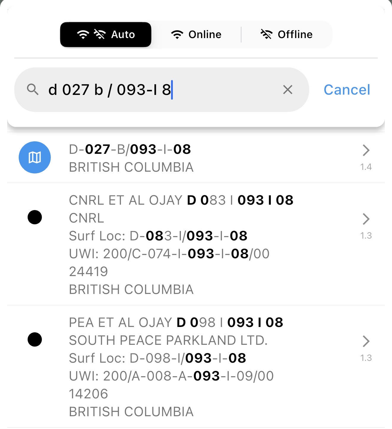
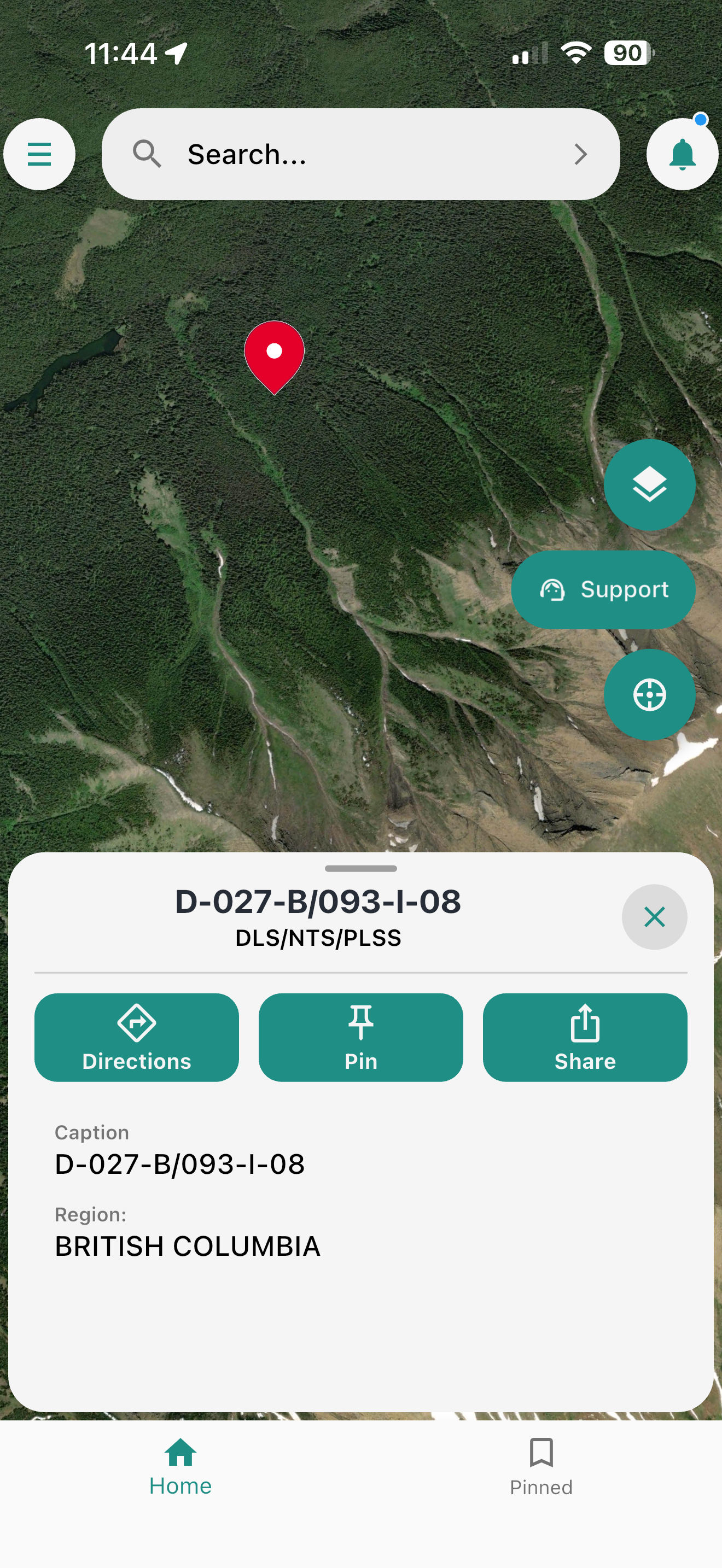
A complete NTS wellsite location looks like this: D-027-B/093-I-8.
That reference contains six hierarchy levels. Read from broad to specific, they are Series, Map Area, Map Sheet, Block, Unit, and Quarter Unit. In the written wellsite string, the detailed portion is shown first: Quarter Unit-Unit-Block/Series-Map Area-Map Sheet.
Series: the broad regional sheet
The first part of an NTS address is the Series number. In 093-I-8, the series is 093.
Series sheets cover large portions of Canada, each spanning about 8 degrees of longitude and 4 degrees of latitude. They are the starting point for any NTS lookup, a broad regional anchor before you zoom in.
Oilfield work in northeast British Columbia commonly falls under series 093 and 094.
Map Area: the lettered block
Within each series, the map is divided into 16 lettered blocks running A through P, arranged in a specific pattern across the sheet. In 093-I-8, the map area is I.
The lettering starts in the southeast corner of the series sheet and proceeds east in rows, snaking up through the sheet, similar to the way sections snake within a DLS township.

Map Sheet: the numbered unit
Each map area is divided into 16 numbered units from 1 to 16, again in a snaking pattern. In 093-I-8, the map sheet is 8.
This level is what most people refer to when they say the NTS map sheet. The numbering starts in the southeast corner and snakes up through the rows. It covers an area of roughly 0.5 degrees of longitude by 0.25 degrees of latitude, a sheet large enough that you still need the next level of detail to find a wellsite.

Block: the lettered subdivision
For British Columbia well locations, each NTS map sheet is further divided into 12 blocks lettered A through L. In D-027-B/093-I-8, the block is B.
This is the first petroleum-specific subdivision below the standard NTS map sheet. If you skip the block letter, the rest of the location no longer lines up correctly.

Unit: the numbered square
Each block contains 100 units numbered from 1 to 100. The numbering starts in the southeast corner of the block and runs right to left across each row. In the example, 027 is unit 27 inside block B.
Quarter Unit: the final parcel
Each unit is split into four quarter units labeled A, B, C, and D, starting in the southeast corner. In D-027-B/093-I-8, the quarter unit is D, which is the northeast quarter of unit 27.
This is the most specific level of the BC NTS well location and the parcel used to identify the surface site in the legal description. Knowing the full NTS string, series, map area, map sheet, block, unit, and quarter unit gives you a defined geographic reference that can be translated into a navigable location.

Putting it all together
Once you stack those pieces in order, the full NTS address becomes much easier to read. The series, map area, and map sheet place you in the right regional map tile, then the block, unit, and quarter unit narrow the location down to the final parcel.

How NTS and DLS compare
If you have already worked with DLS coordinates in Alberta or Saskatchewan, here is what changes with NTS.
DLS is a land survey system. It measures and divides land into physical sections based on survey lines. NTS is a map sheet system. It indexes geographic areas based on topographic map tiles.
In practical terms, that means DLS gives you a precise land parcel defined by survey stakes, while NTS gives you a map reference that points to a defined geographic cell. Both get you to the right area, but NTS coordinates are most commonly used in British Columbia oilfield work where the DLS grid does not apply.
If you work across both systems, the most important thing to know is that they are not interchangeable. A DLS string like 04-16-042-07W5 and an NTS string like D-027-B/093-I-8 describe locations in completely different ways, and each requires a tool that understands the right system to translate it correctly.
Field workflow: how to navigate to an NTS location
Once you understand the hierarchy, using an NTS coordinate in the field follows the same general pattern as any wellsite navigation job.
Step 1: Get the complete NTS string before you leave
Make sure you have every component of the address from dispatch, the work order, or the customer. A string like D-027-B/093-I-8 is only useful if each part is present and accurate.
Step 2: Use a routing tool that understands NTS
Consumer navigation apps, like Apple or Google Maps, do not know what D-027-B/093-I-8 means. They are built for street addresses and cannot translate a map sheet reference into a routable destination. You need a tool built for oilfield location formats.
Oilfield Route supports NTS well searches alongside DLS and UWI. You can enter the NTS reference, confirm the surface location on the map, and generate a route before you head out, including on roads that do not appear in general mapping tools.
Step 3: Confirm the surface location, not just the well reference
The same rule that applies to DLS and UWI also applies to NTS: the well reference and the surface location are not always the same point. On directional or horizontal wells, the NTS reference in the regulatory record may describe the bottom hole location. The access road, gate, and wellhead are at the surface location.
Before you start the route, confirm that you are routing to the surface location shown in the well details, not just to the grid reference.
Step 4: Download your maps before you go
Northeast British Columbia and other areas where NTS coordinates are common often have limited or no cell coverage. If you are working in that region, download the area maps in Oilfield Route before leaving the yard. Once they are on the device, you can search, confirm, and navigate offline without depending on a live signal.
Install it now and keep routing when the signal drops
Choose your device, download the regional map package for your operating area, and head out with offline routing ready before you lose coverage.
The bottom line
BC NTS well locations follow a clear hierarchy: Series, Map Area, Map Sheet, Block, Unit, and Quarter Unit. Read them from broad to specific, use a routing tool that can translate the reference into a navigable surface location, and download your maps before you lose signal.
If you are moving between Alberta DLS work and British Columbia NTS work, Oilfield Route handles both systems in the same app. You can search by DLS, UWI, or NTS, confirm the surface location, and head out with routing ready before coverage drops.
If you need help confirming a location or coverage area, use the contact page and the team can help you verify the workflow before your next run.